

bathymetry
(bathymetric measurements)
Bathymetric lidar technology can be used in both shallow coastal waters and deep oceans to record the topography of the seafloor. The resulting point clouds can be used to create nautical charts, plan shipping routes, explore oil and gas deposits, and collect environmentally relevant information about the seafloor.
The term bathymetry refers to the surveying of the topographic shape of seabeds and water beds. Whereas in the past, the creation of bathymetric maps relied exclusively on surveys using handheld lead solders or depth sounders, nowadays LIDAR systems make it possible to create precise 3D images underwater much more efficiently. Due to the strong refraction of the water, the laser beam is strongly scattered during underwater propagation, which affects image quality. When using simple LIDAR sensor technology, such measurements are limited to waters with shallow to medium water depth and low turbidity. Accurate calibration of the lidar sensor and GPS receivers can help minimize inaccuracies due to waves and reflections.
However, there are also several techniques that can be used to minimize this interference, so that such measurements can even be made from satellites:
- Atmospheric correction: Some bathymetric lidar sensors use a technique called "atmospheric correction". This involves correcting for the reflection of laser light off air molecules in the atmosphere to obtain accurate range measurements.
- Multi-frequency Lidar: some lidar sensors use multiple laser frequencies to minimize the influence of waves and reflections on the water surface. By using multiple laser frequencies, wave reflections can be identified and filtered out to obtain more accurate measurements.
- The use of special filters: there are special filters that can be applied to the measurement data to minimize interference from waves and reflections. For example, statistical filters can be used to detect and remove outliers in the measurement data.
By combining these techniques (and more), bathymetric lidar sensors can produce accurate point clouds of the seafloor even when waves and reflections are present on the water surface.
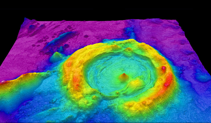
Image: High-resolution multibeam lidar map showing spectacularly faulted and deformed seafloor geology, in shaded relief and coloured by depth, by NOAA Ocean Exploration & Research, licensed under the Creative Commons Attribution-Share Alike 2.0 Generic license via Wikimedia Commons.